Forecasts play key roles in many people’s lives, from planning picnics at the park, to cancelling flights and avoiding weather-related tragedies. Because weather can be a life-or-death matter, researchers work hard to develop new technology and ways to provide earlier and more accurate forecasts.
Scientists and engineers at NASA’s Langley Research Center in Hampton, Virginia, are combining satellite images with novel algorithms to monitor hazardous thunderstorms. With this method, they can identify where severe winds, hail or tornadoes are more likely to occur within storm clouds.
“We are able to analyze the locations where severe storms most frequently occur and when they occur with unprecedented detail using commonly available satellite imagery,” said Kristopher Bedka, a physical scientist at NASA Langley. Bedka leads a team of researchers that study hazardous thunderstorms with satellites across the globe from the National Oceanic and Atmospheric Administration, NASA and other international agencies.
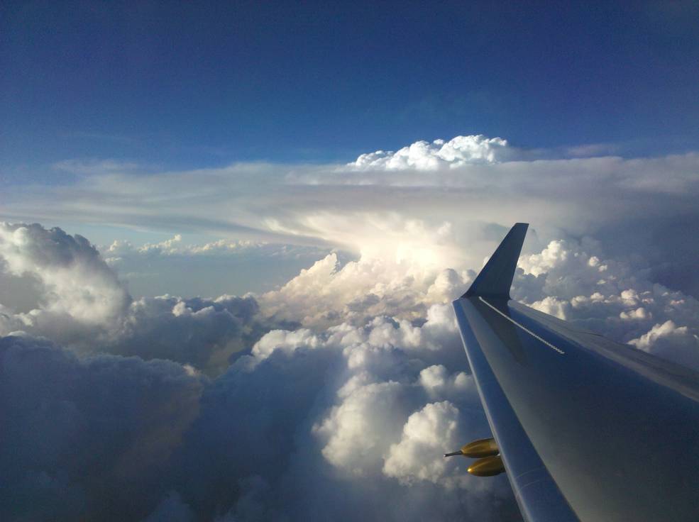
Thunderstorms form when warm, moist air rises rapidly into the atmosphere. These air currents produce cloud formations known as cumulonimbus incus, or anvil clouds, which look similar to an atomic bomb explosion with a flat and wide top. The flat anvil tops form because when updrafts rise through the lowest layer of the atmosphere, they hit the layer above, known as the stratosphere, without penetrating it. These updrafts usually flatten wide and spread under the stratosphere, but some of them are intense enough to punch through the stratosphere. These extreme updrafts, Bedka said, are the ones forecasters should be most concerned about.
Forecasters have known for years that anvil clouds indicate thunderstorms. But anvil tops can be miles wide, and it is sometimes difficult to distinguish where within those clouds hazardous weather may be occurring. Bedka said it is crucial to figure out what is a hazardous storm and what isn’t within anvil clouds, especially because strong updrafts pose serious risks for things like flying aircraft.
“You never really want to fly through turbulence, but you can’t tell a forecaster or a pilot: ‘don’t fly anywhere here,’” said Bedka as he pointed at satellite images of cloud tops over southern United States on his computer screen. “That’s half the state of Texas and all of Oklahoma, so you really want to target where within these clouds is most likely to be unsafe.”
To really target the action, Bedka focuses on updrafts that are strong enough to punch into the stratosphere. That penetration creates lumpy clouds, which look almost like the top of a cauliflower sticking out from an anvil top. Known as overshooting tops, these lumps indicate areas where strong thunderstorms—sometimes hail and tornadoes—usually occur.
Although researchers know that overshooting tops indicate thunderstorms, Bedka said it is sometimes difficult to spot them quickly enough to provide warnings for severe weather. “You can see some of these clouds with your eyes in satellite imagery, but given that the images are changing so rapidly, you need a tool that can automatically identify them to make better forecasts,” he said.
“You can imagine monitoring a storm throughout its lifetime, whether it has overshooting tops and how these tops relate to weather on the ground,” Bedka said. “But you could maybe do that for like one storm, and what you really want is to identify whether there’s an entire line of severe weather events corresponding to each of those little bumps.”
Bedka works with Langley researcher Konstantin Khlopenkov. Analyzing sunlight reflected from clouds allows them to see the signature cauliflower shapes of overshooting tops. Bedka and Khlopenkov also use infrared imagers that function like night-vision goggles to detect heat. These imagers can spot overshooting tops, which emit less heat than other clouds in lower regions of the atmosphere.
To deliver almost instant forecasts, Bedka and Khlopenkov combine their satellite observations with powerful software engineering. “We can process an image that covers the entire United States in less than two minutes,” Bedka said.
Bedka sees tremendous value in overshooting tops research, which he said could make a difference for thousands of people worldwide under various situations. “In the U.S. we are fortunate in that we can track hazardous storms using weather radar data,” he said. “But many regions in the world do not have these radars, so satellite imagery and hazardous storm detection products like mine are often the only data that forecasters can use to warn the public.”
Bedka has studied overshooting tops over the African Great Lakes in East Africa. There, abrupt temperature changes along the shores of small and massive lakes create thunderstorms that kill thousands of people every year. Bedka found that storms over these lakes almost always occur during the night, which is especially dangerous to fishermen who remain on the lakes for days at a time.
In Europe, insurance companies are using Bedka’s data to identify areas where hazardous storms are more likely to happen, which can affect insurance pricing. And in the United States, his research provides valuable and unique data on storm locations over oceans, where very few other datasets for forecasting storms exist. His team is also finding that flying too close to overshooting tops can result in unsafe flying conditions for aircraft due to turbulence and engine icing.
Bedka has been studying overshooting tops since 2008 with various satellites. He was a lead developer of overshooting top detection algorithms for GOES-R, a weather satellite that will launch in October 2016 and that he and other researchers will use in part to deliver more accurate severe weather forecasts.
Roberto Molar Candanosa
NASA Langley Research Center
Last Updated: May 6, 2016
Editor: Joe Atkinson
Taken during the Deep Convective Clouds and Chemistry campaign, the image above shows a side view of an intense updraft punching through a cumulonimbus cloud “anvil.”
Credits: The Deep Convective Clouds and Chemistry (DC3) field campaign


