DETROIT – Tuesday night was one of those rare occasions where the large-scale ingredients needed for severe storms simply did not exist, but a tornado developed anyway and caused damage in Taylor.
Atmospheric instability was weak, and wind speeds both at low and mid-levels were also unimpressive.
If we look at these radar images from 11:00 p.m., 11:45 p.m. and 12:15 a.m., you see a thunderstorm with heavy rain moving northward toward Wayne County.
Now notice what happened quickly between 12:40 and 12:45 a.m.: a hook echo developed in the radar imagery, suggesting a circulation and possible developing tornado.
A short time later, the hook echo was gone.
It appears that the tight curving circulation around low pressure traveling across southeast Michigan, perhaps combined with outflow winds from one of the thunderstorms, may have generated enough localized wind shear to spin up this brief tornado.
The tornado’s winds are estimated to have been 80 miles per hour, which categorizes it as an EF0 tornado on the zero-to-five Enhanced Fujita Tornado Intensity Scale.
It had a total path length of only eight-tenths of a mile, was 100 yards wide, and was on the ground for less than two minutes.
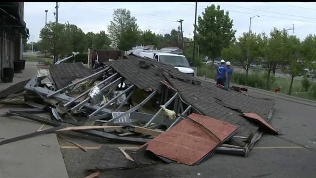
Wayne County Emergency Management officials surveying the damage report that the quick touchdown damaged three buildings, including partial roof damage, displacement of a roof air conditioning unit, damage to a business sign, and some small tree damage.
A lot of people will ask why there was no warning. Yes, our Doppler radars give us data about the wind field inside of a thunderstorm and, in the case of those large, devastating tornadoes, the circulation develops well in advance of the tornado touching down and we can sometimes give you ten to fifteen minutes of notice BEFORE the tornado develops.
However, small, brief tornadoes are sometimes very difficult to detect. Plus, they happen so briefly that it is impossible sometimes to give advance warning. Also remember that the National Weather Service doesn’t just issue a warning the moment they first see rotation…there is a procedure in place to verify the circulation over a couple of radar scans to reduce false alarms.
In the case of Tuesday night’s tornado, they were watching and ready to trigger the warning, which they did right around the same time the tornado developed. It happened that quick, and was over in moments. There was nothing more they could have done.
by Paul Gross (2018, August 1) ClickOnDetroit

